

VisualGPS 4.2
Display specific NMEA 0183 sentences and analyze effects
Program info
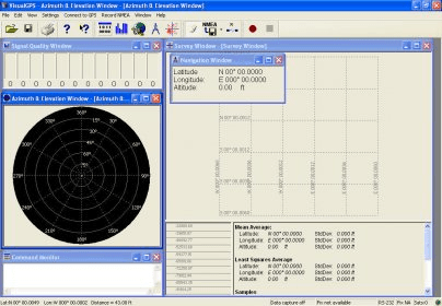
Work with satellite imagery in the multi-device suite. View all satellites, analyze the azimuth and elevation graph display for each of them, check the HDOP and VDOP parameters, etc. Monitor satellite signals, verify their eye on latitude, longitude, altitude, etc.
VisualGPS incorporates many advanced features found in professional programs. Its sole purpose is to display graphically specific NMEA 0183 sentences and show the effects of selective availability (SA).
Main Features:
- Azimuth and Elevation Graph - View all satellites that are in view. Each satellite identifies its pseudo random number (PRN) and its azimuth and elevation. Also plot and print the physical mask angle.
- Survey - The survey window displays both position and xDOP (HDOP and VDOP) parameters. The ability for user selectable HDOP/VDOP color thresholds for position averaging make a great utility. Also monitor Standard Deviation and effects of Selective Availability. That's not all - print the results graphically. (Click here for example print output) (in PDF format - 157K)
- Signal Quality/SNR Window - Monitor satellite signal to noise ratios and see them graphically on the screen. The signal quality window will grow or shrink to accommodate number of satellites in view
- Navigation - Monitor latitude, longitude and altitude
- NMEA Command Monitor - View NMEA sentences as they are received More
Details
Extensions

No information available
The data will be available later.Awards

There are no awards
Over time, app awards will appear here.


Comments