VisualGPS incorporates many advanced features found in professional programs. Its sole purpose is to display graphically specific NMEA 0183 sentences and show the effects of selective availability (SA).
Main Features:
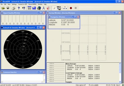
- Azimuth and Elevation Graph - View all satellites that are in view. Each satellite identifies its pseudo random number (PRN) and its azimuth and elevation. Also plot and print the physical mask angle.
- Survey - The survey window displays both position and xDOP (HDOP and VDOP) parameters. The ability for user selectable HDOP/VDOP color thresholds for position averaging make a great utility. Also monitor Standard Deviation and effects of Selective Availability. That's not all - print the results graphically. (Click here for example print output) (in PDF format - 157K)
- Signal Quality/SNR Window - Monitor satellite signal to noise ratios and see them graphically on the screen. The signal quality window will grow or shrink to accommodate number of satellites in view
- Navigation - Monitor latitude, longitude and altitude
- NMEA Command Monitor - View NMEA sentences as they are received
Requirements:
- GPS Receiver connected to a RS-232 port with NMEA 0183 output - NMEA demo file included for those who do not have a GPS receiver
- Windows 2000 sp4, Windows XP, Vista or Windows 7
- 486 100MHz or higher microprocessor
- SVGA at least 1024X768 resolution
- 16 megabytes of RAM
- 6 megabytes of disk space
- One available RS-232 port (or captured NMEA text file - included)


Comments (1)